The Total Eclipse of 2 August 2027 From Your Town
The card above starts on a town guessed from your device’s time zone, or on the town a link names; type yours and pick it. It gives the share of the Sun the Moon covers at its deepest on your town’s clock, how far away the path of totality is and in which direction, the town inside it that the distance points to and how long totality lasts there, then your own four contact times.
Open totality over Luxor, 2 August 2027
Opens the poster pictured below, in your browser: no account, nothing uploaded. Downloads: a vector SVG, a 300 dpi PNG and a PDF at the real size you pick.
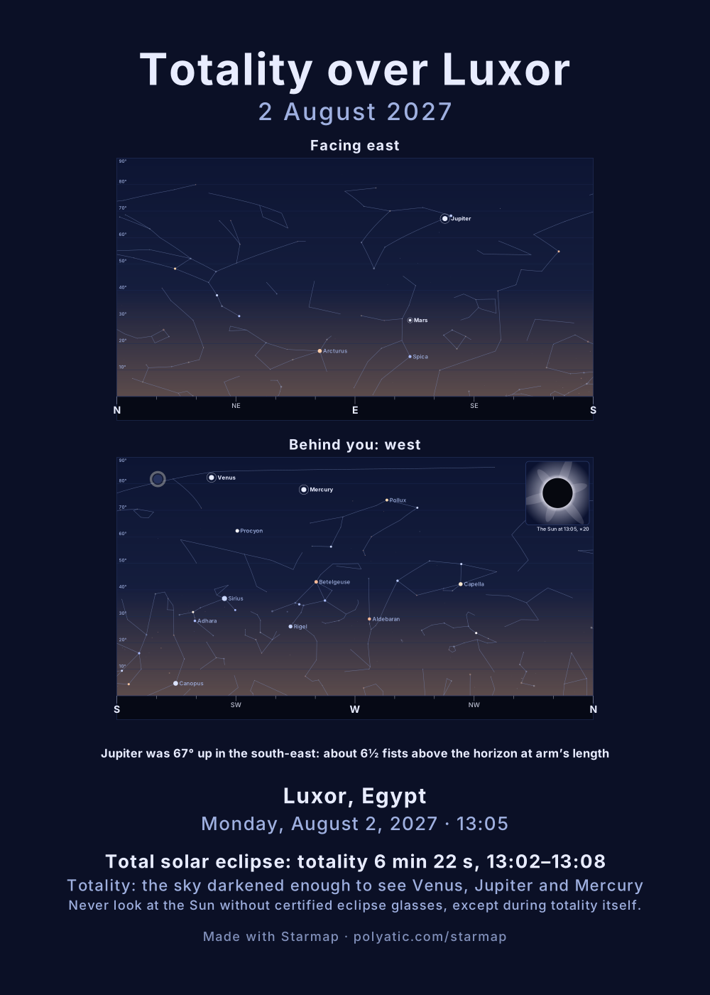
Never look at the Sun without certified eclipse glasses, except during totality itself. Sunglasses, smoked glass and exposed film are not filters. A pinhole in a card, throwing a small image of the crescent onto a sheet of paper, can be watched for as long as you like.
Where the shadow goes, minute by minute
The Moon’s dark shadow touches down in the open Atlantic at 08:25 Universal Time and races east. It crosses the Strait of Gibraltar at 08:48 UT, where the band is 237 km wide and its central line gets 4 min 53 s; skims the coasts of Morocco, Algeria and Tunisia, passing 113 km south of Tunis; crosses Libya by Benghazi and reaches the Nile valley about an hour after Gibraltar. There the shadow is slowest over the ground and the Sun nearly overhead, and totality on the central line peaks at 6 min 23 s around 10:00 UT. It then crosses the Red Sea near Jeddah at 10:26 UT, Yemen and the tip of Somalia, and leaves the Earth over the Indian Ocean at 11:48 UT. Outside the band, from Iceland to Iran, the eclipse is partial.
Totality town by town
Eight places people plan around, computed by the same engine as the card above. Each is the town list’s centre point; a few km across the band changes the answer, as Málaga shows.
| Town | Totality lasts | Total from–to | Maximum, Sun’s height |
|---|---|---|---|
| Tarifa, Spain UTC+2 | 4 min 37 s | 10:45–10:49 | 10:48, 38° |
| Cádiz, Spain UTC+2 | 2 min 46 s | 10:45–10:48 | 10:47, 37° |
| Málaga, Spain UTC+2 | 1 min 38 s | 10:48–10:50 | 10:49, 39° |
| Ceuta, Spain UTC+2 | 4 min 47 s | 10:45–10:50 | 10:48, 38° |
| Tangier, Morocco UTC+1 | 4 min 50 s | 09:44–09:49 | 09:47, 38° |
| Tunis, Tunisia UTC+1 | partial, 97 % | — | 10:10, 55° |
| Benghazi, Libya UTC+2 | 6 min 9 s | 11:28–11:34 | 11:31, 68° |
| Luxor, Egypt UTC+3 | 6 min 22 s | 13:02–13:08 | 13:05, 82° |
Durations run from second to third contact with the IAU lunar radius, k = 0.272281 Earth radii, the convention of NASA’s eclipse canon and of the distance line on the eclipse list; sites using the larger mean radius list up to about 20 s more near the edges. Contacts are read as a clock reads them, the maximum to the nearest minute, and the Sun’s height is its true altitude without the air’s bending. Tunis misses totality: it is 113 km outside the path and sees 97 % of the Sun covered at 10:10.
Across the band, not along it, is what matters. Málaga lies just inside the northern limit and gets 1 min 38 s; Ceuta, on the far side of the Strait and close to the central line, gets 4 min 47 s. Along the band the central duration keeps growing, from 4 min 53 s at Gibraltar to 6 min 23 s in Egypt, because the shadow’s footprint moves more slowly where the Sun stands higher.
98 % is not totality
From Sevilla the Moon covers 98 % of the Sun at 10:48. Totality is 71 km south, and Jerez de la Frontera, 78 km away, gets 1 min 18 s of it. That is near the path’s edge, where totality is brief: Algeciras, 147 km away and near the central line, gets 4 min 25 s. Getting inside the path is the whole difference. At 98 % the light turns thin and metallic and shadows sharpen, but the sky stays blue and the sliver of Sun left is still far too bright to look at. Only when the last of it goes do the corona and the planets appear.
How the map is drawn
The band is the engine’s own: the central line and the two limits are worked out every 2 minutes of the shadow’s track, from the same Sun and Moon positions as every figure on this page, and drawn here without smoothing. The land outline is Natural Earth’s 1:110m set, which is public domain and coarse: coasts are generalised by several km and small islands are missing. The map is a flat latitude-longitude grid stretched for 36.5° N, so distances far north or south of the Strait look a little off. Read the km from the card’s line, which is measured on the globe, not with a ruler on the map. Towns north of 58° N or outside the frame get a marker on its edge.
What the poster of your moment shows
The button opens the star-map generator on your town at the eclipse’s maximum in the Horizon view: two panels of sky, the one facing east and the one behind you, with the sky dimmed by the share of the Sun that is covered, as dark as deep twilight in totality. An inset magnifies the Sun twenty times so the Moon’s disc on it can be seen, and the caption names the eclipse and its times and carries the eye-safety sentence. The stars are the 1,630 of the Yale Bright Star Catalogue, each placed for 2027 by precession. Their own proper motion is not modelled, and over a few decades it would move none of them visibly. Dates before 15 October 1582 are read in the Julian calendar, should you draw an eclipse from history. The Milky Way is drawn as a soft band under the stars, five steps from its faint edge to its brightest star clouds, and clipped at the horizon like everything else. Its centre line is the galactic equator, computed with the same math as the stars, so it runs where the sky has it: through Cygnus, Aquila and Sagittarius in a northern summer, through Auriga, Gemini and Puppis on a winter night. Its edges and star clouds are a hand-drawn sketch of the naked-eye band, not a traced photograph, so treat them as a guide to where to look, not a brightness map; a checkbox turns the band off. The Moon is drawn at its real altitude, azimuth and phase for your moment, and left off entirely when it was below your horizon. So are the five naked-eye planets: Mercury, Venus, Mars, Jupiter and Saturn are drawn where they stood, sized by how bright each was that night, labelled, and shown only when above your horizon. The Sun is drawn too whenever it was above your horizon, and the line under the chart says whether that moment was daylight, civil, nautical or astronomical twilight, or full dark, with the Sun’s altitude: the stars are always drawn where they stood, even when daylight or twilight hid them. If your moment falls inside a solar or lunar eclipse seen from your place, the eclipse is drawn as well: the Moon over the Sun, to scale, or the Moon in the Earth’s shadow. Uranus, Neptune and 133 deep-sky objects are one switch away: tick Deep-sky objects and the chart marks all 110 Messier objects and 23 southern and binocular showpieces (Omega Centauri, 47 Tucanae, both Magellanic Clouds, the Carina Nebula and more) with star-atlas symbols and labels such as M31 and M42, and adds Uranus and Neptune — open this page’s example with it ticked. Most of them are binocular targets: only a handful, such as M31, M42, M45 and Omega Centauri, show to the naked eye from a dark site, Uranus (about magnitude 5.7) only to a sharp eye, and Neptune (about 7.8) only in binoculars. Great comets since 1900 can be added (Hale-Bopp over London, 1997). Not drawn: faint comets and satellites, whose orbits this tool does not compute.
For every eclipse from your town until 2035, solar and lunar, see every eclipse from your town.
Common questions
Why do other sites give my town a few seconds more or less?
Four reasons, all small. The Moon’s radius: this page uses k = 0.272281, the convention of NASA’s canon, while the larger mean radius (0.2725076) widens the path and adds up to about 20 s near its edges. The Moon’s edge: mountains and valleys on its limb move the contacts by 1 to 3 s, and this page, like most, treats the edge as smooth. The Earth’s rotation: the engine takes the difference between atomic and Earth-rotation time, ΔT, as 76 s from the Espenak–Meeus formula, while the Earth has lately run at about 69 s; each second of ΔT shifts the whole path about 0.4 km east or west at these latitudes. And where you stand: a town’s centre is not your square, and this page assumes sea level.
What happens to the sky during totality?
In the last seconds the crescent breaks into beads of light along the Moon’s valleys, then a single bright point, the diamond ring. When it goes, the sky drops to the darkness of deep twilight. The corona, the Sun’s outer atmosphere, stands round the black disc in pale streamers, and red prominences may show at its edge. Venus, Jupiter and Mercury come out near the Sun, the brighter stars soon after, and the horizon glows orange all round, because beyond the shadow the Sun is still shining on the air. The temperature falls by a few degrees. On 2 August 2027 the Sun is 38° up at Tarifa and 82° up at Luxor, nearly overhead.
How do I watch it safely?
Never look at the Sun without certified eclipse glasses, except during totality itself. Use glasses or a hand viewer certified to ISO 12312-2, check them for scratches, and put them on before you look up. During totality, and only then, take them off: the corona is safe to see. When the first bead of sunlight returns, look away and put them back on. A camera, binoculars or telescope needs its own solar filter over the front lens; eclipse glasses behind an eyepiece do not protect you.
Is my location sent anywhere?
No. The first town is guessed from your time zone’s name, never from your position. The town list loads from this site, and the eclipse, the distance to totality and the map’s markers are worked out on your own device.